Geolocation information is saved as metadata in EXIF (Exchangeable Image File Format) files embedded in each image. Longitude and latitude are added to classic information: date, time, camera, focal length, aperture, sensitivity, etc. Only cameras that natively integrate a GPS module, or that are associated with an external receiver, can memorize the positions of the camera when triggering.
It is also possible to geotag photos manually by dragging and dropping them on a map, as long as you remember where they were taken. Software, applications or even online services make it possible to use this information to retrace, for example, a trip or a hike on a geographical map, to share it with your friends, etc.
1. Flickr: locate your photos online
We no longer present the famous Internet photo-sharing service bought by Yahoo! in 2005. In recent months, the service has offered no less than 1 TB of free space for storing photos and videos. The community site has many tools, including geolocation. To upload photos to Flickr, you must have or open a free account.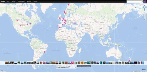
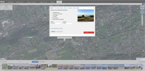
When uploading your images, you have the option to tag them, add a title, description, etc. For geolocation, the service allows each image to be placed on Yahoo Maps, via the “Organize” tool. Select the "Map" menu to drag and drop your photos one by one onto the map. If your photos are correctly geotagged, the service automatically positions them where they were taken. If necessary, you have to zoom in on the map to place it where you want it.
On each geotagged photo appears a small icon and a number allowing them to locate their location on the map and to open them. You can choose from three viewing modes (map, hybrid and satellite) and save your map using the “Save your map” function. Click on the "Link to this map" button to be able to share and show your route to your loved ones, for example.
2. DigiKam: manage geolocation locally
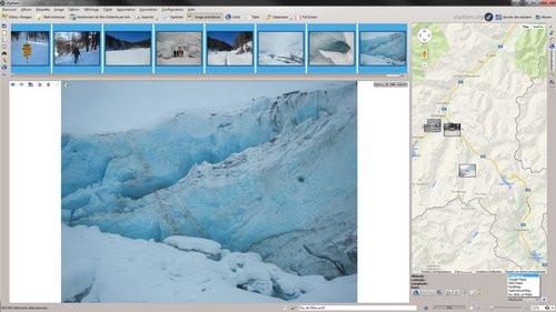
While it's not as well-known as some photo geotagging tools like GeoSetter PhotosGeo2, or Microsoft Pro Photo Tools, DigiKam is open source software definitely worth checking out. Created by a Spanish, it offers a host of possibilities to classify your images and organize them through tags, captions, descriptions, notes, dates, etc. It is particularly interesting for its GPS geolocation tools.The shots that incorporate the EXIF location data (longitude and latitude) can be displayed directly on different mapping services: Google Maps, MSN Map, MapQuestA, etc. It is possible to manually insert GPS coordinates to photos that do not have one using OpenStreeMap or Google Maps. You can display all your geotagged photos on a 3D globe by clicking on "Maps", or export and publish them to one of the aforementioned online mapping services. A remarkable photo manager, however, reserved for advanced users.
3. Koredoko: une application mobile
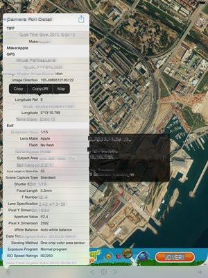
This free application (or € 3,60 without advertising) allows you to view all EXIF information, including the GPS coordinates of photos stored on iOS devices. It manages both photos taken with the mobile terminal and those transferred from another device (compact, reflex, etc.). Compatible only with files in jpeg format, Koredoko provides a very detailed list of EXIF data: camera, focal length, lens, aperture, resolution, size, weight, as well as latitude and longitude when entered natively.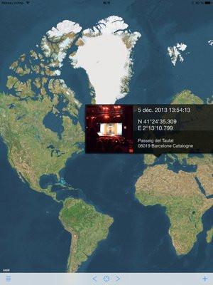
When you launch the app, it automatically displays the last shot in a thumbnail on a map from Google Maps. This is automatically positioned in the right place if, however, it contains GPS coordinates. Otherwise, nothing is lost. Long press the thumbnail and manually place the photo where it was taken to locate it and validate. To access other EXIF information, press the on the "I" icon on the right of the thumbnail.
If you want to save the Google Maps link corresponding to this photo, let your finger press in this area and touch the “Copy URL” contextual menu that appears on the screen. You can then copy this link to Google Maps to find the location, email it to a loved one, etc. Simple and efficient, Koredoko is an excellent tool to taste the joys of photo geolocation.
4. Online photo geolocation services
Locr : essential reference for geocoding services, it has interesting functions such as the implementation of Wikipedia links on the places photographed.Picasa : Google's community photo service is Flickr's main competitor.
Panoramio : on this service also belonging to Google, users share geocoded photos from all over the world.